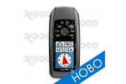


Make a splash with the Basic Handheld GPS receiver Garmin GPS 72H, a lightweight, waterproof handheld that floats. Simple yet robust, the Basic Handheld GPS receiver Garmin GPS 72H features high-sensitivity GPS and a USB connection along with its large screen, simple operation and rock-solid performance.
Find your way effortlessly with the Basic Handheld GPS receiver Garmin GPS 72H's high-sensitivity GPS receiver. Basic Handheld GPS receiver Garmin GPS 72H acquires satellite signals quickly and tracks your location in challenging conditions, such as heavy tree cover or deep canyons.
Don't worry about losing this GPS device in the drink. The Basic Handheld GPS receiver Garmin GPS 72H floats in water, and it's IPX7 waterproof to withstand the accidental dunk or splash in the lake. Whether on water or land, the Basic Handheld GPS receiver Garmin GPS 72H can save up to 500 of your favorite places in memory and point you to your destination (no street or terrain maps).
The Basic Handheld GPS receiver Garmin GPS 72H is NMEA 0183 compatible. To transfer data to your device, Basic Handheld GPS receiver Garmin GPS 72H easily connects to your computer via USB. If you're into boating, hunting or fishing, you can use the 72H's built-in celestial data, which includes sunrise/sunset times and a hunting and fishing calendar.
Basic Handheld GPS receiver Garmin GPS 72H: High sensitivity GPS that floats
| Manufacturer | Garmin |
|---|---|
| Dimensions | 2.7" x 6.2" x 1.2" (6.9 x 15.7 x 3.0 cm) |
| Display size | 4.1 x 5.6 cm, диаг 6.6 cm |
| Display resolution | 120 x 160 pixels |
| Display type | 4 level gray LCD |
| Weight | 218 g |
| Battery | 2 AA batteries (not included) |
| Battery life | 18 hours |
| Waterproof | Yes |
| Floats | Yes |
| High-sensitivity receiver | Yes |
| Interface | serial and USB |
| RoHS version available | Yes |
| Basemap | No |
| Ability to add maps | No |
| Built-in maps | No |
| Built-in memory | 1 МВ |
| Accepts date cards | No |
| Waypoints/favorites/locations | 500 |
| Routes | 50 |
| Track log | 2,048 points, 10 saved tracks |
| Automatic routing (turn by turn routing on roads) | No |
| Electronic compass | No |
| Barometric altimeter | No |
| Touchscreen | No |
| Geocaching-friendly | No |
| Outdoor GPS games | No |
| Hunt/fish calendar | Yes |
| Sun and moon information | Yes |
| Tide tables | Yes |
| Area calculation | Yes |
| Custom POIs (ability to add additional points of interest) | No |
| Unit-to-unit transfer (shares data wirelessly with similar units) | No |
| Picture viewer | No |
| Guarantee | 2 years |