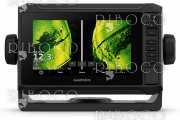


Fully network capable, including Garmin Network and NMEA 2000 (radar, autopilot, instruments, multiple screens, FUSION-Link, sensors, black box sonar, digital switching, thermal cameras, GRID and more), GPSMAP 7416xsv also offers the conveniences of built-in Wi-Fi® connectivity.
Built-in Advanced Sonar Capabilities
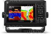
The built-in sonar capabilities of the GPSMAP 7416xsv include 1 kW dual CHIRP sonar, the most sophisticated sonar technology available for the fishing and boating public. It also includes both CHIRP DownVü and CHIRP SideVü scanning sonar that provide nearly photographic sonar images of fish and structure that passes below and to the sides of your boat. DownVü and SideVü provide the clearest scanning sonar images on the water. Also supported are 50 kHz/200 kHz, 77 kHz/200 kHz and Minn Kota and MotorGuide trolling motor transducers (transducers sold separately).
Garmin Marine Network and NMEA 2000 Support
Full-network compatibility allows you to add more to your boat. GPSMAP 7416xsv supports radar, autopilot, instruments, multiple screens, FUSION-Link, sensors, remote sonar modules, digital switching, thermal cameras, GRID™ and more.
Add Array or Dome Radar
You can add your choice of Garmin marine radar, including our powerful xHD2 open array radars or xHD dome radars that pair ease of use with advanced open array features.
Network Sharing
GPSMAP 7416xsv allows you to share features with other compatible GPSMAP units, such as radar, supplemental maps and user data, including waypoints, routes and tracks. User data entered into one chartplotter can be automatically synced with other chartplotters in a network.
Heading, Position Refreshed 10 Times per Second
Fast, responsive 10 Hz GPS/GLONASS refreshes your position and heading 10 times each second to make your movement on the screen more fluid. It makes dropping up to 5,000 accurate waypoints and finding your way back them quick and easy.
Special Sailing Features
Supported sailing features include laylines, enhanced wind rose, heading and course-over-ground lines, true wind data fields and tide/current/time slider. Racing features include pre-race guidance, synchronized race timer, virtual starting line, time to burn and lay line data fields. Gauge displays are designed to provide important need-to-know information at a glance, including true and apparent wind angle, set and drift, true or apparent wind speed, horizontal or vertical graphs, and a data bar with customizable data fields.
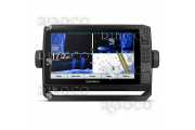
Add Extras with BlueChart g2 Vision
With the optional BlueChart g2 Vision® you can add a whole new dimension of exceptional features to your chartplotter including MarinerEye view and FishEye view provide a 3-D perspective, both above and below the waterline. High-resolution satellite images and aerial photographs help orient you in unfamiliar areas. Auto Guidance technology searches through all relevant charts to create a route you can actually follow — one that avoids obstacles, shallow water, buoys and other obstructions
Compatible with gWind Transducers
gWind, gWind Wireless and gWind Race transducers feature twin-fin technology with 3-bladed propeller. Connect to the NMEA 2000 and compatible Garmin chartplotters via the GND 10 black box bridge.
FUSION-Link Entertainment System
Enjoy the ability to control all compatible FUSION-Link-enabled audio systems directly from your compatible chartplotter display.
Built-in Wi-Fi/ANT
Built-in Wi-Fi/ANT® for use with Garmin Helm™ and BlueChart® Mobile.
View, Control Your Device from a Smartphone or Tablet
Garmin Helm allows you to view and control your compatible chartplotter from a compatible smartphone or tablet while providing enhanced situational awareness for the mariner. Easily switch between portrait and landscape mode to accommodate mounting preferences. When using an iPhone® or iPad®, you can even record a movie of your chartplotter screen to share with friends and family.
Get Onboard with BlueChart Mobile
With BlueChart Mobile 2.0, a free app downloaded from the App Store™, you can get reliable weather information while you plan marine routes on your iPad or iPhone then wirelessly transfer them to your boat’s compatible networked Garmin chartplotter. Continue to acquire current weather information from your cellular-based Apple® device and stream that data onto your chartplotter screen. Even if you don’t have a Garmin chartplotter, you can still take advantage of the tremendous features of BlueChart Mobile on your compatible Apple device.
Enhanced Auto Guidance
Just enter the location where you want to go and patented Garmin Auto Guidance technology instantly searches through relevant charts to create a safe virtual pathway on the display that helps you avoid low bridges, shallow water and other charted obstructions en route.
Better still, with enhanced Version 2.0, you now have access to even more features and capabilities. You’re able to adjust the calculated Auto Guidance pathway by inserting “via” points at interim stops or landmarks along your desired route. You can easily review hazard points along your calculated path. And you can even engage your compatible Garmin autopilot to follow the Auto Guidance route, automatically. Other 2.0 enhancements give you the ability to calculate arrival times at any point on your route (great for timing arrivals to correspond with bridge openings and other time-critical events). Better still, you can now save your plotted Auto Guidance paths for future navigation by backing them up on an SD™ card with your BlueChart® g2 Vision® or Lake Vü™ HD Ultra cartography¹.
Simplified SOS Calling
This exclusive SOS safety assist feature makes it easier for anyone – even those not familiar with marine electronics or radio protocols – to quickly call for Coast Guard help in an emergency. By simply tapping the SOS button on the chartplotter’s touchscreen display, your networked Garmin VHF radio will automatically tune to the Channel 16 emergency frequency and a list of possible situations (Ffire, man overboard, etc.) will be displayed. Once the applicable choice has been selected, the screen will provide a Coast Guard approved VHF radio distress call script, along with the ship’s current lat/long GPS coordinates, that can be read off to responders – thus saving time, averting panic, and providing the essential information needed by rescuers to assure the best possible outcome.
GPX Waypoints Transfer
If you have waypoints, tracks or frequently used routes stored on another manufacturer’s GPS product – or on a Garmin handheld device – now it’s easier than ever to transfer those items to your new Garmin chartplotter, via industry-standard GPX software formatting. GPX is an open standard format for GPS data exchange across platforms and applications. With this easy-to-use interface technology, Garmin has taken “no waypoint left behind” to a whole new level of trade-up convenience.
Special Sailing Features
To help you gain a wind-maximizing competitive edge, your chartplotter features a pre-race guidance page that shows your virtual starting line, along with data fields showing laylines, time to burn before the start and a race timer that can be synchronized across all your networked Garmin GPS products. In addition, other supported sailing features include an enhanced wind rose, heading and course-over-ground lines, set and drift, true and apparent wind data and more. You can also use available built-in wireless connectivity to access and control a variety of marine-specific apps via compatible smartphones or tablets.
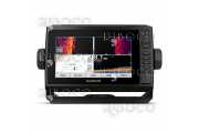
Panoptix™ Down Transducer
With 1 Panoptix Down transducer, you get 3 remarkable views, allowing you to actually see fish and bait swimming around under your boat – in real time. You can even see fish in the water column in 3-D, from the bottom to the surface. You can be stationary yet still see things in 3-D below your boat.
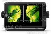
LIVEVÜ DOWN
Shows real-time moving sonar images below the boat. This screen shows bait drop echo trail movement in purple with sonar history data at left.
REALVÜ 3-D DOWN
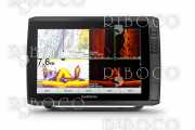
Scans the area below the boat from front to back and side to side. This screen shows a school of fish sitting against the back side of vertical face, on Pport side of boat 35 feet deep.
REALVÜ 3-D HISTORICAL
Scrolls through the data as the boat moves to show the history of entire water columns – from the bottom to the surface and all of the fish in between. This screen shows the boat passing over a stream channel with a school of fish between 30 to 40 feet.
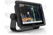
Panoptix Forward Transducer
One Panoptix Forward transducer provides 2 impressive views, even while your boat is stationary. It shows the bottom plus fish and bait swimming in the water column in front of your boat – in real time. You can even see your lure as you reel it in. You can also get 3-D views of fish and structure in front of your boat.
LIVEVÜ FORWARD
Updates are provided with a single ping, providing real-time moving images of what’s in the water. This screen shows a large target (a diver) approaching the boat.
REALVÜ 3-D FORWARD
Digitally scans the area in front of the boat, creating a forward-looking 3-D view of the bottom, structure and fish. This screen shows fish targets at 10 feet and drawing bottom depth of 20 feet.
iPhone and iPad are trademarks of Apple Inc., registered in the U.S. and other countries. App Store is a service mark of Apple Inc. Android and Google Play are trademarks of Google Inc. Wi-Fi is a registered trademark of the Wi-Fi Alliance.
| Manufacturer | Garmin |
|---|---|
| Dimensions | 42.7 x 27.4 x 8.6 cm |
| Display size | 34.5 x 19.3 cm; 39.6 cm diagonal |
| Display resolution | 1366 x 768 pixels |
| Display type | WXGA |
| Weight | 4300 g |
| Battery | not applicable |
| Battery life | not applicable |
| Waterproof | Yes |
| Basemap | Yes |
| Ability to add maps | Yes |
| Built-in maps | No |
| Built-in memory | No |
| Accepts date cards | 2 SD™ cards |
| Waypoints/favorites/locations | 5000 |
| Routes | 1000 |
| Track log | 50,000 points; 50 saved tracks |
| Sun and moon information | Yes |
| Tide tables | Yes |
| 3-D card | No |
| Guarantee | 2 years |