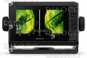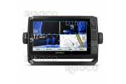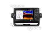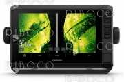


GPSMAP 721xs combination chartplotter/sounder allows for easy visibility, day or night. Whether it is flat, flush or bale-mounted, it will be the focal point of your helm. It has media integration and autopilot compatibility, radar support, and NMEA® 2000 and wireless connectivity. It includes our hallmark user-friendly interface as well as a worldwide basemap.
With the integration of a 10 Hz GPS/GLONASS receiver, the 721xs refreshes position and heading up to 10 times per second. It displays constant and fluid on-screen location and proves to be incredibly accurate when marking waypoints and navigating.
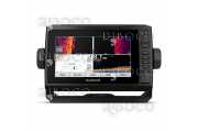
Built-in support for a wide selection of Garmin transducers, including 50/200 kHz, 77/200 kHz, DownVü and SideVü scanning sonar and CHIRP. In addition, it will also support Minn Kota® and MotorGuide® trolling motor transducers.
Add the optional GCV™ 10 black box sonar to enjoy Garmin DownVü and SideVü scanning sonar with the clearest scanning sonar images on the water.
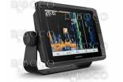
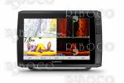
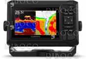
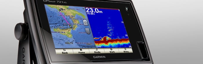
When used with a compatible CHIRP transducer (sold separately), GPSMAP 721xs displays crystal-clear sonar images to help find the next hidden fishing spot, ship wreckage or diving location. Garmin CHIRP sonar allows you to see target separation and resolution at extraordinary depths, and dial into specific frequencies to target certain species of sport fish. Bottom contours are more visible, and signal noise can be suppressed at greater depths to provide a more timely interpretation of what’s below for safer navigation and better fishing.
This combo allows you to add more capabilities to your boat. It provides NMEA 2000 support so you can see valuable information on your screen for autopilot, engine data, SiriusXM weather and more.
Add your choice of marine radar, either open array or our new xHD dome radar that pair ease of use with advanced open array features.
The GPSMAP 721xs offers select networking capabilities that allow you to share features with other compatible GPSMAP units such as supplemental maps, and user data including waypoints, routes and tracks. User data can be automatically synced with other chartplotters in the network.
Supported sailing features include laylines, enhanced wind rose, heading and course-over-ground lines, true wind data fields and tide/current/time slider.
The GND 10 black box interface seamlessly integrates Nexus instruments and sensors with the Garmin family. It converts data between the Nexus network and NMEA 2000 to provide trouble-free compatibility between Nexus and Garmin products, including gWind™ and gWind Race wind transducers.
Garmin gWind, gWind Wireless and gWind Race transducers feature twin-fin technology with 3-bladed propeller. Connect to the NMEA 2000 and compatible Garmin chartplotters via the GND 10 black box bridge.
With BlueChart Mobile, a free app downloaded from the App Store™, you can plan marine routes on your iPad® or iPhone® then wirelessly transfer them to your boat’s compatible networked Garmin chartplotter¹. Even if you don’t have a Garmin chartplotter, you can still take advantage of the tremendous features of BlueChart on your Apple device.
Garmin Helm™ is a free app that allows you to view and control your compatible Garmin chartplotter from an iPhone or iPad — while providing enhanced situational awareness for the mariner. Easily switch between portrait and landscape mode to accommodate mounting preferences. Using your Apple digital mobile device, you can even record a movie of your chartplotter screen to share with friends and family! Download from the App Store today.
In the box:
•GPSMAP 721xs
•Power/data cable
•Bail mount and knobs
•Flush mount kit
•Protective cover
•Documentation
| Manufacturer | Garmin |
|---|---|
| Dimensions | 9.0" x 5.6" x 2.4" (22.9 x 14.2 x 6.1 cm) |
| Display size | 6.0" x 3.6", 7.0" диагонал (15.2 x 9.1 cm, 17.8 cm диагонал) |
| Display resolution | 800 x 480 pixels |
| Display type | Multi-touch touchscreen WVGA display |
| Weight | 1000 g |
| Battery | not applicable |
| Battery life | not applicable |
| Waterproof | Yes |
| Basemap | Yes |
| Ability to add maps | Yes |
| Built-in maps | No |
| Built-in memory | No |
| Accepts date cards | 2 microSD™ cards (not included) |
| Waypoints/favorites/locations | 5000 |
| Routes | 100 |
| Track log | 50,000 points; 50 saved tracks |
| Sun and moon information | Yes |
| Tide tables | Yes |
| 3-D card | Yes |
| Guarantee | 2 years |