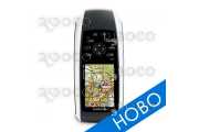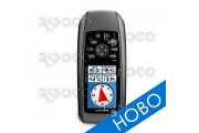


Tap the touchscreen then hit the trail with Handheld GPS Navigator Garmin Oregon 450t. This next-generation handheld features a rugged, touchscreen along with preloaded topographic maps, 3-D map views, a high-sensitivity receiver, barometric altimeter, electronic compass, microSD™ card slot, picture viewer and more. Even exchange tracks, waypoints, routes and geocaches wirelessly between similar units.
Handheld GPS Navigator Garmin Oregon 450t leads the way with a tough, 3" (7.62 cm) diagonal, sunlight-readable, color, touchscreen display that offers crystal clear enhanced colors and high-resolution images. Its easy-to-use interface means you’ll spend more time enjoying the outdoors and less time searching for information. With user-selectable dashboards, you can customize the appearance of your display. Both durable and waterproof, Handheld GPS Navigator Garmin Oregon 450t is built to withstand the elements: bumps, dust, dirt, humidity and water are no match for this rugged navigator.
Oregon's preloaded U.S. or European topographic maps, 3-D map view and a built-in worldwide basemap with shaded relief give you all the tools for serious climbing or hiking. Map detail includes national, state and local parks and forests along with terrain contours, elevation information, trails, rivers, lakes and points of interest. Just in case you’re wondering how steep that hill really is, Oregon’s 3-D map view helps you visualize your surroundings — giving you a better perspective of the elevation.
With Handheld GPS Navigator Garmin Oregon 450t you can share your waypoints, tracks, routes and geocaches wirelessly other compatible Oregon, Colorado® and Dakota® users. Now you can send your favorite hike to your friend to enjoy or the location of a cache to find. Sharing data is easy. Just touch “send” to transfer your information to similar units.
Handheld GPS Navigator Garmin Oregon 450t supports OpenCaching.com GPX files for downloading geocaches and details straight to your unit. By going paperless, you're not only helping the environment but also improving efficiency. Oregon stores and displays key information, including location, terrain, difficulty, hints and descriptions, which means no more manually entering coordinates and paper print outs! Simply upload the GPX file to your unit and start hunting for caches. Show off photos of your excursions with Oregon’s picture viewer. Slim and lightweight, Oregon is the perfect companion for all your outdoor pursuits.
Handheld GPS Navigator Garmin Oregon 450t has a built-in 3-axis tilt-compensated electronic compass, which shows where you're heading even when you’re standing still, without holding it level. Its barometric altimeter tracks changes in pressure to pinpoint your precise altitude, and you even can use it to plot barometric pressure over time, which can help you keep an eye on changing weather conditions. See changes in your elevation ahead of you and where you've been with enhanced track navigation. With its high-sensitivity, WAAS-enabled GPS receiver and HotFix® satellite prediction, Oregon 450t locates your position quickly and precisely and maintains its GPS location even in heavy cover and deep canyons.
Conveniently plug in optional preloaded microSD cards for all your outdoor activities on land or water (see the Maps tab for compatible maps). Just insert a MapSource® card with detailed street maps, and Oregon provides turn-by-turn directions to your destination. Access whitewater runs or explore equestrian trails by purchasing U.S. Trailmaps for Whitewater and Equestrian. Or, you can add regional, detailed trail and lake information with our TOPO U.S. 24K maps. With BlueChart® g2, you’ll get everything you need for a great day on the water, including depth contours, navaids and harbors. The card slot is located inside the waterproof battery compartment, so you don't have to worry about getting it wet.
You've been busy exploring and now you want to store and analyze your activities. With a simple connection to your computer and the Internet, you can get a detailed analysis of your activities and send tracks to your outdoor device using Garmin Connect™. This one-stop site offers an activity table and allows you to view your activities on a map using Google™ Earth. Explore other routes uploaded by millions of Garmin Connect users and share your experiences on Twitter® and Facebook®. Getting started is easy, so get out there, explore, and share.
Handheld GPS Navigator Garmin Oregon 450t: Touch the great outdoors.
| Manufacturer | Garmin |
|---|---|
| Dimensions | 2.3" x 4.5" x 1.4" (5.8 x 11.4 x 3.5 cm) |
| Display size | 3.8 x 6.3 cm, диаг 7.6 cm |
| Display resolution | 240 x 400 pixels |
| Display type | transflective color TFT touchscreen |
| Weight | 193 g |
| Battery | 2 AA batteries (not included); NiMH or Lithium recommended |
| Battery life | 16 hours |
| Waterproof | Yes |
| Floats | No |
| High-sensitivity receiver | Yes |
| Interface | USB and NMEA 0183 compatible |
| RoHS version available | Yes |
| 3-axis compass | Yes |
| Basemap | Yes |
| Ability to add maps | Yes |
| Built-in maps | Yes |
| Built-in memory | 850 MB |
| Accepts date cards | microSD™ card (not included) |
| Waypoints/favorites/locations | 2000 |
| Routes | 200 |
| Track log | 10,000 points, 200 saved tracks |
| Automatic routing (turn by turn routing on roads) | Yes |
| Electronic compass | Yes |
| Barometric altimeter | Yes |
| Touchscreen | Yes |
| Geocaching-friendly | Yes |
| Outdoor GPS games | Yes |
| Hunt/fish calendar | Yes |
| Sun and moon information | Yes |
| Tide tables | Yes |
| Area calculation | Yes |
| Custom POIs (ability to add additional points of interest) | Yes |
| Unit-to-unit transfer (shares data wirelessly with similar units) | Yes |
| Camera | No |
| HotFix satellite prediction | Yes |
| Photo navigation (navigate to geotagged photos) | No |
| Guarantee | 2 years |